
Traffic Safety
Dangerous by Design: Mapping Unsafe Roads in ANC 5B
I want my city to become a place where you can let go of your child's hand.
Anne Hidalgo, Mayor of Paris
Our streets are not safe. Reckless and inattentive drivers, wide roads, narrow or nonexistent sidewalks, missing ADA-compliant ramps, short crossing signals, outdated roadway design, and a lack of bike lanes are all part of what make our roadways dangerous.
Compounding these conditions is the fact that it can often be difficult, if not impossible, to get traffic safety improvements approved for many streets in our community. The city’s failure to design or modify so many roadways in a way that discourages dangerous driving, accounts for the prevalence of poor driver behavior and human error, and improves safe transit conditions increases the risk of preventable harm to residents.
To document the prevalence of dangerous roads in our community, Commissioner Prita Piekara (5B03) and I have created a map to visually portray where residents tend to feel the least safe. Zoom in and click on the icons to see what your neighbors are saying about our roads. You can also view this map here.
To add a street or intersection to this map, please fill out the Google form to the right and we will manually update the map. (Please give us a little time to input the data.)
LET US KNOW: Which roads seem unsafe to you?

13th Street + Upshur :
Stop Signs
For decades, the intersection of 13th + and Upshur Streets NE has been controlled by a two-way stop. In recent years, higher traffic volumes and speeding have contributed to an increase in car crashes here. Unfortunately, multiple requests by neighbors to secure traffic calming measures were unsuccessful. To demonstrate the need for traffic safety improvements, in 2017, we began to document every single traffic crash at this intersection.
After documenting over a dozen crashes at this intersection over a two-year period, we were finally able to win approval by DDOT for the installation of a four-way stop in 2020.
Since the four-way stop was installed in summer 2020, there have been no new car crashes, and neighbors who previously avoided this intersection now report that they feel safe driving and walking across 13th Street at Upshur.
13th Place + Upshur : Wheelchair Ramps
The intersection of 13th Place + Upshur Street has long suffered from a confounding problem: it had a wheelchair ramp only at one corner, but not the other three, making it unsafe—if not impossible—for neighbors who rely on wheels to cross the street. Compounding this problem was the fact that the intersection is controlled by a two-way stop, and drivers on 13th Place often speed through the intersection, jeopardizing pedestrian safety. Situated just one block away from Bunker Hill Elementary School, and in a neighborhood with a growing population of both seniors and young families, this lack of standard pedestrian safety infrastructure was unsustainable.
After first raising concerns about this issue in late 2018, in summer 2020, we were able to get new wheelchair ramps and crosswalks installed along Upshur Street not only at 13th Place, but also at Sargent Road and 13th Street, ensuring pedestrians can cross all three intersections safely.

13th Street / Sargent Road: Truck Traffic
13th Street and Sargent Road are truck-restricted roadways, subject to a prohibition of through trucks over 1.25 tons. Signs noting these restrictions are posted at Michigan Avenue and S. Dakota Avenue. Despite these posted restrictions, these roads nevertheless see a high volume of truck traffic, most of which appears to be attributable to drivers using 13th Street/Sargent Road as a shortcut to get to their destinations.
Of particular concern to residents is the fact that a high-pressure, 24” gas transmission line runs beneath this roadway. (By comparison, the gas service line connecting to your home is often no more than 2” in diameter.) Accordingly, residents worry that the vibrations from excessive truck traffic could weaken the roadway and utility infrastructure.
The Metropolitan Police Department’s (MPD) Motor Carrier Safety Unit has conducted some enforcement actions on this road. However, officers with that unit have noted that additional signage along 13th Street and Sargent Road would be helpful in ensuring that the truck prohibition is clearly posted and that citations issued to drivers will be upheld in court.
To address MPD’s concern regarding the apparently-inadequate signage, I requested that additional truck restriction signs be posted along 13th Street and Sargent Road, at the intersections of Upshur, Varnum, and Allison Streets NE, facing both north- and southbound traffic.
These signs were installed in January 2021, and MPD’s Motor Carrier Safety Unit has since begun conducting enforcement actions along this road to reduce unwarranted truck traffic.
Michigan Avenue Corridor
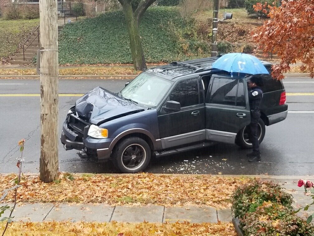
The Michigan Avenue corridor in Northeast D.C. has long been besieged by dangerous driving, poor pedestrian and cyclist visibility, long pedestrian crossing distances, short signal timing, and other features that make this roadway dangerous for all users, particularly those using more vulnerable modes of transportation.
Following a fatal, cyclist-involved collision on March 1, 2021, I led a community-wide letter to DDOT, joined by more than 150 residents, elected officials, and civic leaders. In our letter, we urged DDOT to swiftly implement desperately-needed traffic safety improvements along the Michigan Avenue corridor in Northeast D.C.
Read below for updates on which intersections in ANC 5B05 DDOT plans to make safer.
10th / Bunker Hill Rd / Michigan
In August 2020, DDOT issued a Notice of Intent to make several traffic safety improvements at the intersection of 10th Street, Michigan Avenue, and Bunker Hill Road NE. Among other changes, DDOT will:
Install a left-turn arrow for northbound 10th Street traffic turning west onto Michigan Avenue;
Install a curb extension on Bunker Hill Road at 10th Street to reduce the crossing distance across Bunker Hill Road;
Expand the south side of the triangular park and reduce parking on Bunker Hill Road to “enhance pedestrian safety, vehicular visibility and give back to the green space area taken for the turn lane.”
These changes were completed in April 2021.

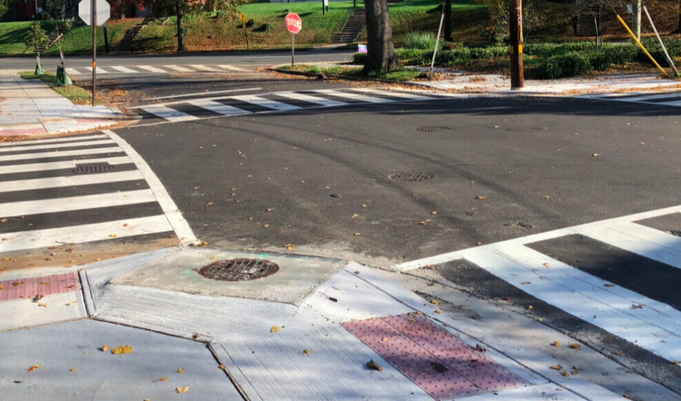
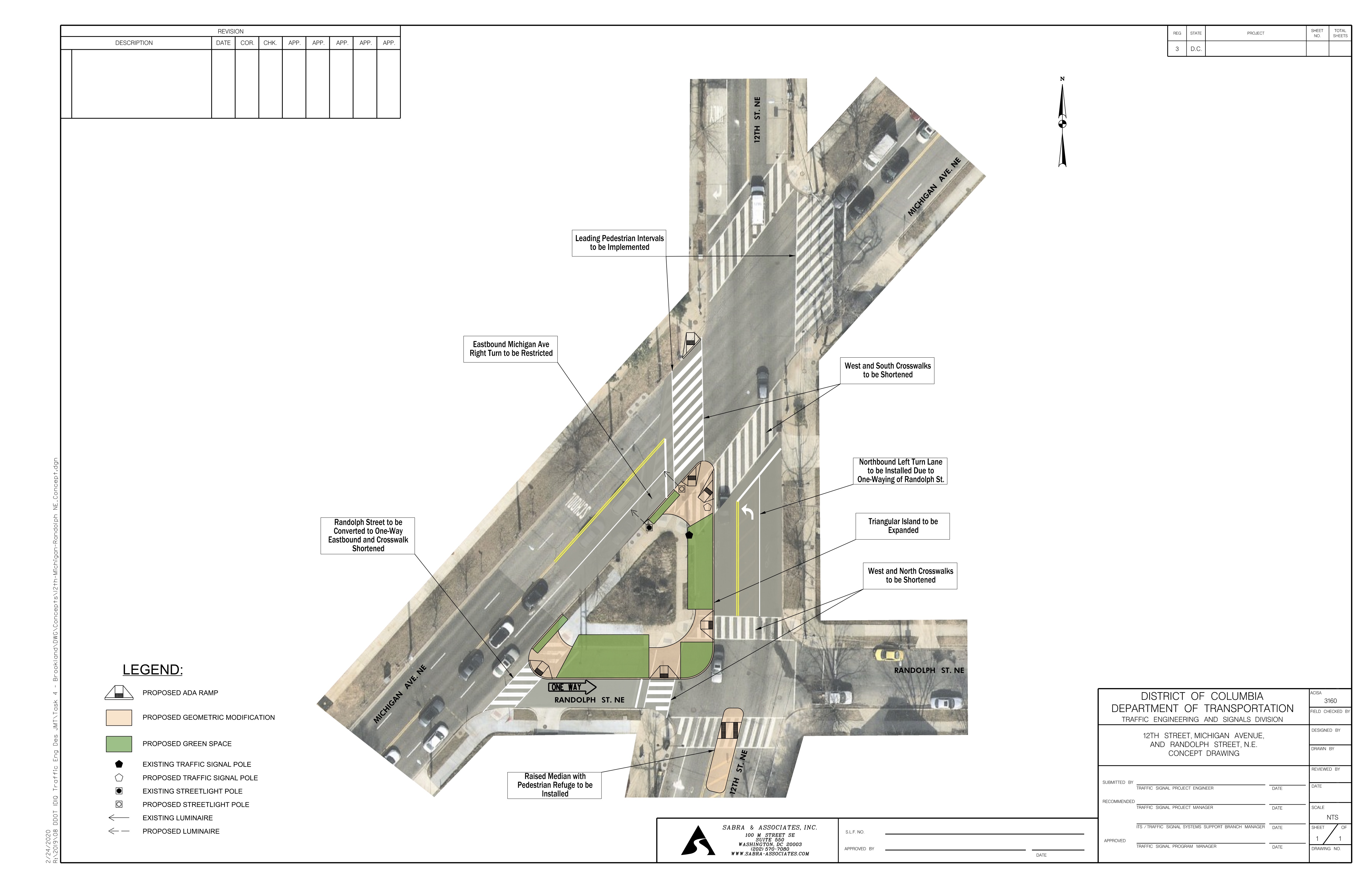
12th / Randolph / Michigan
In March 2021, DDOT issued a Notice of Intent to make several traffic safety improvements at the intersection of 12th Street, Randolph Street, and Michigan Avenue NE. Among other changes, DDOT will:
Install a left-turn arrow for northbound 12th Street traffic turning west onto Michigan Avenue;
Convert Randolph Street to one-way eastbound between Michigan Avenue and 12th Street NE;
Expand the triangle median to reduce the crossing distance across Randolph Street and 12th Street (*Note: I confirmed that this change will not result in the removal of any legal parking spaces, as parking is already prohibited in the affected areas);
Restrict right turns from Michigan Avenue onto 12th Street southbound; and
Install a leading pedestrian walk signal that will allow pedestrians to begin crossing Michigan Avenue while traffic is stopped in all directions.
To view a larger version of this image, click here.
These changes were completed in the summer of 2021.
13th / Taylor / Michigan
A confluence of speeding motorists and confusing and poorly-timed traffic signals make the intersection of 13th Street + Taylor Street + Michigan Avenue (13TM) one of the most dangerous, crash-prone intersections in SMD 5B05. 13TM also suffers from limited and unsafe pedestrian passages across Michigan Avenue, often causing pedestrians to get “stranded” at the trianglular median between Taylor + Michigan—where car crashes frequently occur.
I have been working with neighbors and DDOT to secure expedited and sorely-needed traffic safety improvements at this busy and confusing intersection to improve safety for residents, pedestrians, and motorists.
In March 2021, DDOT issued a Notice of Intent to make several improvements to this intersection. Specifically, DDOT proposes to:
revise traffic signal timing and sequencing;
expand the concrete triangle bounded by 13th Street, Michigan Avenue, and Taylor Street;
convert the northbound approach of 13th Street at Taylor from a single through and single left lane to a shared through/left lane;
add a new crosswalk on the west side of the intersection across Michigan Avenue; and
install a curb extension at the northeast corner of 13th and Taylor Streets.

To view a larger version of this image, click here.
These changes were completed in the summer of 2021. (Note: DDOT still must install some improved traffic signal heads, which have been delayed due to supply issues. Accordingly, that aspect of the project has not yet been completed.)