
Zoning + Development
Planning and Zoning 101 Training
On May 13, 2021, I co-hosted a joint Single Member District meeting with my colleague, Commissioner Prita Piekara (5B03), for residents to learn more about District land use planning policies and zoning laws. Guests from the Office of Planning and the Office of Zoning conducted presentations to help untangle these topics and address residents’ questions and concerns. You can view those presentations, as well as a recording of the training, below.
Guest Presenters
Office of Planning | Ms. Evelyn Kasongo, Lead Planner, Wards 1, 5 | Presentation
Office of Zoning | Ms. Allison E. Myers, General Counsel | Presentation
Video Recording
Planning + Zoning FAQs
What is the Comprehensive Plan?
The Comprehensive (“Comp”) Plan is a birds-eye-view planning document that lays out the District’s priorities for public investments in a number of areas over the next 20 years. The Plan express expectations for how land use is likely to change over time, and will be used to guide public investments in areas like housing, transportation, parks and recreation, education, health services, and other resources.
The Comprehensive Plan was first adopted in 2006 and later amended in 2011. In 2016, Mayor Bowser proposed a mid-term revision of the Comp Plan, ostensibly to reflect demands of a growing population on city infrastructure and housing supply, among other resources. After conducting public engagement, in 2018, the city finalized the “Framework Element” of the Comp Plan—a general statement of priorities meant to guide the development of the rest of the plan. The Council approved those changes in late 2019.
Also in late 2019, the city presented additional proposed changes to the Comp Plan, including changes to the Future Land Use Map (FLUM), as well as elements pertaining to transportation, housing, the environment, public parks and recreation, education, and others. Over the next few months, OP engaged with residents and Advisory Neighborhood Commissions (ANC) and incorporated their input into the mayor’s proposal, which was sent to the Council for consideration in April 2020. The Council reviewed, amended, and passed the Comp Plan in May 2021.
How much opportunity has the public had to weigh in on the Comp Plan?
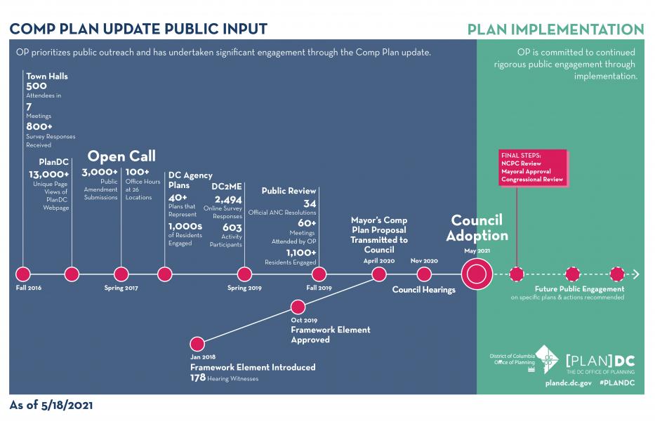
Since 2016, the Office of Planning (OP) has engaged with residents at town hall and ANC meetings, and it received more than 3,000 Comp Plan amendments from the public. You can view a chart of OP’s engagement process below.
Did ANC 5B weigh in on proposed changes to the Comp Plan and Future Land Use Map (FLUM)?
Yes, to a degree. After changes to the FLUM were introduced in October 2019, ANC 5B passed a resolution (which you can find here) and submitted it on behalf of our community to the Office of Planning in January 2020. (The Brookland Neighborhood Civic Association also submitted input, which you can find here.) The Office of Planning acknowledged or adopted nearly all of the ANC’s recommendations. Additionally, most of those changes were kept in the final version of the Comp Plan approved by the Council in May 2021.
It is important to note that although the Comp Plan proposed a number of changes throughout ANC 5B, the Commission’s resolution only focused on Howard Divinity and the area adjacent to the Brookland-CUA Metro Station. Significantly, ANC 5B did not opine on proposed land use changes to any parcels of land within SMD 5B05. As a result, ANC 5B forfeited its opportunity to ask the Council and Office of Planning to approve, reject, or amend proposed land use changes to these parcels, very much to the detriment of residents of SMD 5B05. Below is a side-by-side comparison of the land use map in ANC 5B before and after the Comp Plan was adopted.

Land use map for ANC 5B before the Comp Plan was revised in 2021.

Land use map for ANC 5B after the Comp Plan was revised in 2021.

Brookland Lanes Historic Preservation Review Board Case (3700 block of 10th Street NE)
Urban Investment Partners (UIP), the owner of several parcels of land on 10th Street between Michigan Avenue and Perry Place, proposes to build a new mixed-used residential-commercial development that will replace the existing 10th Street shopping plaza across from Turkey Thicket Recreation Center.
One of the buildings in this space is the Atlantic Electric Supply Corporation, formerly known as the Brookland Bowling Alleys. This building is both a District and national historic site. Accordingly, UIP must present its proposed design to the Historic Preservation Review Board (HPRB), which will consider the “height, proportions, materials, the level and nature of demolition and the alteration of character-defining features. The Board does not consider use, light, air, noise, privacy, traffic, views per se, the removal of trees, etc.” UIP’s HPRB hearing is tentatively scheduled for June 23, although there is a possibility it could get postponed until July.
Residents can view UIP’s application for its proposed project here; residents can view images of the proposed project here.
Brookland Lanes FAQs
Will this project be a Planned Unit Development?
No. Unlike many other recent developments in our community (e.g., the Reed Street development), the developer does not intend to seek a Planned Unit Development (PUD) for this space. (A PUD would allow a developer to increase the height and/or density of a project beyond what would be permitted by right, in exchange for community benefits.) UIP instead intends to build "by right," which means that it does not intend to seek zoning exceptions that would allow UIP to build a larger structure than is already permitted within the zone where these buildings are located. The maximum height the developer is permitted to build to under current zoning limits is 50’.
Because UIP is not seeking to do a PUD, the community won't have the same kind of opportunity to negotiate community benefits as we've done with large projects like the St. Joseph's Seminary development and the Reed Street development. Nevertheless, residents may wish to share their views as to how they hope the commercial space will be utilized so that UIP better understands market demands in our area.
What will happen to the existing tenants?
According to UIP, several of the existing tenants have leases that run until summer 2024, which UIP intends to honor. UIP has said that this project is in the very early stages and that it does not intend to break ground on this project until summer 2024. I’ve been told that District Vet intends to remain as a tenant in the new building, as it has a long-term lease that will run past summer 2024. The developer says it will work with District Vet to figure out how to allow it to continue its operations during construction. I have also strongly urged UIP to ensure that it allocates suitable space in the new development for a childcare center, given the enormous demand for childcare in the neighborhood. UIP’s property manager has met with Petit Scholars to discuss lease options.
What role does the ANC play in this process?
ANCs are entitled to “great weight” in matters that come before the HPRB, so long as the ANC’s input falls within HPRB’s jurisdiction. HPRB only considers the “height, proportions, materials, the level and nature of demolition and the alteration of character-defining features” of a proposed structure. “The Board does not consider use, light, air, noise, privacy, traffic, views per se, the removal of trees, etc.” In order to be given great weight on this project, the ANC’s feedback must fall within these parameters.
I held a public meeting for residents on June 14 to learn about the project and share their views. Notice of this meeting was disseminated through my email list, the Brookland listserv, my website, and paper flyers for businesses within the affected shopping plaza and residents residing within 200’ of the development. Based on the considerable feedback I received from residents about this project, I introduced a resolution before the full ANC 5B Commission, recommending that HPRB ask UIP to modify its proposed design.
Tell me more about “by-right” development here.
A property owner may build as a matter-of-right, or by-right, if the structure they intend to build does not require a zoning variance, special exception, zoning map amendment, or other approval by the city to exceed what is currently allowed under the zoning code for that parcel of land.
In 2021, the Council and Mayor adopted changes to the Comprehensive (“Comp”) Plan (see “Planning + Zoning 101” section above) to amend what kinds of land uses are allowable on certain parcels of land. A number of land parcels in ANC 5B, and in SMD 5B05, were affected by these changes, including the parcels of land where UIP proposes to build its new building.

Map of allowable land uses in SMD 5B05 before 2021 Comp Plan revisions.


Map of allowable land uses in SMD 5B05 after 2021 Comp Plan revisions.
Prior to the Comp Plan changes, UIP’s land was zoned to allow Production, Distribution, and Repair (industrial) uses and Moderate-Density Commercial uses (left image, above). The Comp Plan amended the zoning map to allow Medium-Density Commercial and Medium-Density Residential uses (right image, above). This change allows for slightly increased height/density, and it eliminates the PDR/industrial use in exchange for allowing residential use instead. Specifically:
Medium-Density Commercial (C-MED) defines shopping and service areas where retail, office, and service businesses are the predominate uses. Buildings are generally larger and/or taller than those in Moderate-Density Commercial areas.
Medium-Density Residential (R-MED) defines areas where mid-rise (4-7 stories) apartment buildings are the predominant use. Pockets of Low- and Moderate-Density homes may exist within these areas.
Because the revised land uses allow the developer to build a slightly larger/taller building, it does not need to request any zoning variances, exceptions, or map amendments to build up to its desired density/height.
Did the ANC weigh in on the Comp Plan changes to these parcels before the Council adopted them in 2021?
No. ANC 5B passed a resolution on the Comp Plan in January 2020 (a year before I took office in January 2021), but the only items the ANC weighed in on were Howard Divinity and the area adjacent to the Brookland-CUA Metro Station. ANC 5B did not opine on proposed land use changes to any parcels of land within SMD 5B05. As a result, ANC 5B forfeited its opportunity to ask the Council and Office of Planning to approve, reject, or amend proposed land use changes to these parcels, very much to the detriment of residents of SMD 5B05.
Howard University Divinity School
Situated in the heart of Brookland, the 23 acre Howard University East Campus is one of the largest undeveloped privately-owned sites in the District of Columbia. It is bounded by 14th Street to the west, Taylor Street to the north, and South Dakota Avenue to the east. The campus was formerly the home of the Holy Name College, built by the Order of Franciscans. In 1985, Howard University acquired the site to house the Howard University School of Divinity. In 2015, the University moved the majority of operations of the School of Divinity to a temporary location on its West Campus, with Mays Hall remaining predominately to house research archives for the School of Divinity.
In 2011, the University published a master plan, which identified the East Campus as an opportunity to raise revenue through real estate assets and enhance academic operations for the University.
In 2016, the University retained the Urban Land Institute (ULI) to conduct a study of the East Campus. The primary purpose of the study was to explore how the site could be used to generate value consistent with the goals of the University and community. The study process included engagement and feedback from University and neighborhood stakeholders. A copy of the study can be found here.
In 2017, Howard University launched a redevelopment process for the East Campus site. The University and its development team launched a community engagement process to get input from the surrounding community and University stakeholders on what redevelopment should look like. You can view more information about that process, and the feedback residents provided, here.
In the Summer of 2018, in preparation for master planning efforts, Howard University worked with its master development team to study existing site conditions. The results of those due diligence efforts can be found here.
Howard University has not announced any recent developments. A Single Member District meeting for residents of 5B02 was held on March 11, to which representatives from the Howard East project were invited to attend. The video of that meeting may be viewed here.
Because Howard University Divinity School is located within Single Member District 5B02, residents who have specific questions regarding the status of this development project are strongly encouraged to contact Commissioner Ursula Higgins (5B02), who remains in contact with the developers. Commissioner Higgins may be reached via email at 5B02@anc.dc.gov, or by phone at 202-321-5289.